Kayaking Sea of Cortez: Sunrise on the Sea of Cortez – Day 2
I awoke early and was able to see a most amazing and unbelievable sunrise on the Sea of Cortez. Just as the sun rose, there was an offshore breeze far in the distance that caused the sun to reflect off the waves in blinding sparkles. As the sun cleared the apparent horizon, I saw some black objects that seemed to be very near and just under the sun. I got my binoculars and looked as close to the sun as I could. As I gazed into the distance just near the sun, there was a glassy mirage with several porpoise appearing and disappearing in midair well above the horizon and appeared to be in the clear sky above the water, but beneath the sun. It was an amazing sight.
Before dawn, I had noticed a panga anchored and floating a couple of hundred yards offshore, apparently unoccupied. To my surprise, just after dawn I noticed some movement and saw a man stand up in the panga. He must have been sleeping in the panga all night and he began to pull on a long rope that extended towards the shore. A few minutes later, as the sun came up, I was able to see a trail of floats leading from the panga toward the shore. Soon I could see that he was retrieving a long gill net that was connected to the shore. Occasionally he stopped to remove a small fish that he threw into the front of the panga. As the sun rose, I searched up and down the shore with my binoculars and I could see many nets were set perpendicular to the shoreline, perhaps all belonging to this fisherman. There were so many nets that I’m surprised that there were any fish left around here at all.
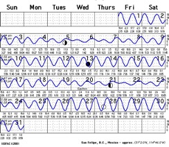
The tide tables that I brought with me seemed to be accurate. By close examination of the recent tide lines on the beach and comparison with the tide tables I was able set my camp on the beach to avoid the high tide during the night without having to drag the heavy kayak too far up the beach. My tide charts showed that the maximum high and low tides were during the dark and full moons. Today was March 6 and the moon was about half full so I would have a few days with minimal tides.
The extreme tides of the Upper Sea of Cortez, combined with the gently sloping coastal plane and offshore regions, create extensive tidal flats where up to several miles of mud/sand flat are exposed during the ebb of spring tides. The long, narrow shape of the Gulf of California creates a “bathtub effect.” The tidal range (amplitude) is very small at the center “nodal point” (near Guaymas), and increases northward and southward from the center, like water sloshing back and forth in an elongate trough. The tidal range is greatest in the narrow, shallow Upper Gulf where water from each tidal flow piles up higher, like in a fjord. The Upper Gulf is thus a highly tidal region, with a maximum tidal range (lowest low to highest high) of approximately 10 m (33 ft).
I was a little sore from my long day of paddling yesterday. I think my adrenaline was pretty high and the excitement of starting the trip kept me going. After I got started paddling this morning, I made a rule that I would stop every hour. That way I would get to see and explore several beaches every day and I would also get the rest I needed to keep going. My first stop this morning was at about 8:00 near a rocky outcrop that I think is at the north end of a campo called Percebu.
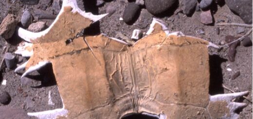
The low cliff next to the beach was a 10-foot-thick layer of shells making up a shell midden created by centuries of seafood collection by the Indians who lived here. They must have loved this place because the extreme tides exposed large rocky areas with lots of shellfish, a constant supply of food. I picked up a nice large conch from the midden, but it seems that their diet was mostly clams and mussels, judging from the large numbers of these shells. There were also some chipped black rocks mixed in with the shells in the midden, probably tool-making debris. The beach and low terrain in this area was mostly sandy soil without any rocky areas. The natives must have brought the black rocks here from someplace farther inland. I did some research and learned that the Indians living this area were part of a group called the Kiliwa tribe. The Kiliwas had constant feuds with neighboring tribes. They especially fought with tribes to the west who restricted travel to the Pacific. The Kiliwa made annual excursions to this area of the Sea of Cortez to supplement their diet with seafood. All fishing was done from the shore, none from boats. Because of the unusually high tides of the northern gulf, the Kiliwa were able to construct fish traps.
By the end of my next hour of paddling, I couldn’t wait to stop because my stomach was growling. I ended up on a long sand dune barrier beach that makes up the edge of Estero Percebu, a very large lagoon. There were lots of broken lobster traps along the crest of the sand dune along with mountains of driftwood at the storm high-tide line. Storms and high surf had washed these traps up from deep water and stacked them in mangled wads of wire and rope on the sand dunes between the open sea and the estero. I wondered if I could repair one of these traps and catch some lobster myself, but that would mean staying around for a day or two to set and retrieve the traps.
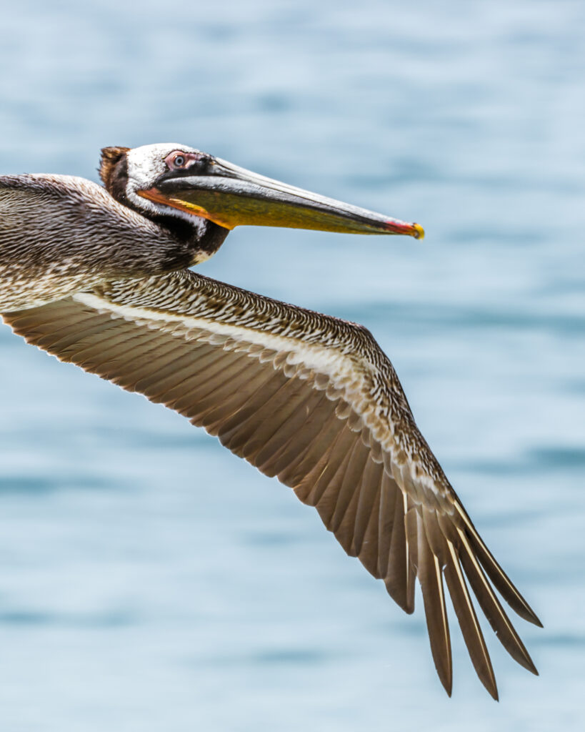
There were some birds in the estero (an estuary), mostly long billed curlews and a semi-palmated plovers. Large groups of pelicans flying by as I came to this landing site. There were groups of 20 to 40 flying in large “V”s. Looking up and down the coast, it was possible to see five to eight group’s flying along the coast at any time.
My frequent stops at one-hour intervals was working fine, but I kept going for an hour at a time for too long. I stopped at a long sand bar at the north end by Bahia Santa Maria, about 23 miles from San Felipe. It was low tide and I saw two guys driving in a truck across a very large, exposed sand bar. To my astonishment, they began setting a gill net from the back end of a truck as they drove on the beach. The flat surface of the sand bar was exposed by the low tide and they set the entire net on the dry sand from the back of the truck. Then drove to higher ground to wait for the incoming tide to cover the net. Dry land fishing! I think this must be the modern version of what the Kiliwa Indians were doing for centuries along this coast. Unfortunately, modern fishing methods include shrimp trawls on the sea floor, traps for lobster, gill nets set along the shore, and dry land fishing. It seems to me the fishing industry in the upper Sea of Cortez can’t be sustainable.
Ahead of me I could see a scattering of houses along a long low bluff. Some of the houses looked large and well cared for, with stairs to the beach, patios, and arches. At the north end of Bahia Santa Maria, there were several very large new houses in a row that seemed to me to have been built very close to the high tide line. A berm had been recently constructed out of sand, apparently to protect them from the 19 ft. tide that came in the previous Thursday, as shown in my tide charts. From what I could see, all it would take would be a good wind with some waves and a moderately high tide and these houses could all be washed away. Climate change, global warming, and projected sea level rise would certainly seem to be a problem for these homes.
By mid-afternoon I began to look for an isolated part of the beach where I could camp. When I stopped for a rest two Americans came down to talk to me. Both of these guys were firemen, formerly with the Huntington Beach Fire Department. They each have a house on the beach and come down here from January to April or May. One guy stays into July, but it’s too hot for the other one. Their campo has a brackish water well, so they buy bottled drinking water and pay 7 pesos for 5 gallons, which seems very cheap. They asked me if I wanted to camp at their place, which was what I probably should have done, but I decided to continue down the coast. Finally, a couple of miles farther down the beach, I was exhausted so I stopped and pulled the kayak up on the beach at an area where most of the houses were boarded up.
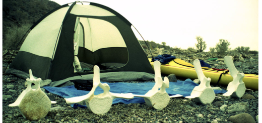
As I traveled along the shore traveling south from San Felipe, it seems like the decor for lawn furniture at the homes that I could see wasn’t complete unless they have major pieces of whale bone somewhere on the property. Jaw bones stuck in the ground to form a portal over a gate or door were the architectural element of choice here!
I went to talk to the person in the nearest house just to make sure that it was OK for me to sleep on the beach in front of his place. The guy who came out of the house was carrying a big steak and looked like he was headed for a barbecue. I asked if it was OK if I slept down on the beach and he said “Yah Yah, want a beer?” Sounded like he was from Minnesota.
The beach was very shallow, and the tide was going out so that meant that I had to haul the kayak a long way up to make sure that the high tide would not catch me later in the night. I got settled in at about 5:30 in the evening, just before dark.
The weather today on the Sea of Cortez was light winds with high clouds in the morning. The clouds got thicker all day.
Next: Day 3 – Just How Far is the Horizon?
Please comment on Two Miles to the Horizon
Back to the beginning of Two Miles to the Horizon


2 Responses
[…] March 6, Day 2 – Sunrise on the Sea of Cortez […]
[…] March 6, Day 2 – Sunrise on the Sea of Cortez […]