
Sea of Cortez: Two Miles to the Horizon- Introduction
Gaze upon the Baja Peninsula and the Sea of Cortez from outer space, and you’ll be struck by its awe-inspiring jagged finger-like shape that spans an incredible 850 miles. Mountainous ridges of bare earth, fiery lava, and rugged granite jut out defiantly, as if daring any onlooker to come closer. The unrelenting sun beats down mercilessly, causing the rocky terrain to sizzle and shimmer in the heat. At times, the heavy winds whip through the region with a deafening roar, only to fall eerily silent the very next moment.
The Sea of Cortez heaves and swells in sync with the lunar cycles, its restless surface an endless dance of light and shadow. There’s no place quite like this land of contrasts, where the stark, unyielding geology, relentless sun, and scarce water resources combine to create an environment that’s both isolating and dangerous. At every turn, danger and isolation lurk in equal measure, beckoning only the most daring and intrepid souls.
Living in southern California most of my life, Baja had always been a place of mystery and adventure. My notion of travel in Baja California was shaped by the stories of the legendary bad roads, vast desert areas with no water, visions of flat tires, cars buried in sand up to their axles, and banditos. Even now, the first question most people ask about traveling in Baja is, “How was the road?”
About five years earlier, we discovered that my wife had some distant relatives living in La Paz and Cabo San Lucas, both near the tip of Baja. We acted on an invitation and drove down to La Paz for our first exploration of the peninsula. For almost 30 years now, Highway 1 has connected cities and small outposts along the length of Baja, so it has become more accessible to everyone. The road between the border and Ensenada is pretty good, followed by about 15 miles of potholes south of Ensenada. Then the road gets better and has very light traffic except for the occasional oncoming large bus or truck that seem to take up more than their share of the road. Away from Highway 1, there still remain places of mystery and discovery, isolated by what seem to be impossible roads and sand traps. Once we got to the desert area around Catavena, with its incredible desert vegetation, we found the desolate beauty of Baja to be overwhelming. I was hooked.
Over the next three years, we made several trips down the length of Baja California on Highway 1. I had recently taken up sea kayaking and I spent a week kayaking by myself in the area around Bahia de Los Angeles in the Sea of Cortez about 425 miles south of the border. Surfing the Internet for information about kayaking in Baja, I came across a book by Ed Darack called Wind Water Sun, A Solo Kayak Journey Along Baja California’s Desert Coastline. “A Solo Kayak Journey”, the words were like magic to me. When I was able to get the book, I couldn’t put it down until I had read it from cover to cover, twice. Darack’s adventure was something that I wanted to experience and I quickly adopted kayaking the length of Baja as one of my life’s goals.
Finding time for life’s goals, of course, is sometimes difficult. I had just had my 60th birthday, and, personally, I was beginning to feel the pressure of time. Shortly, it seemed, I would no longer be able to achieve the goal of a Baja kayaking adventure, especially one that was so demanding. Planning, it seems, is one of my shortcomings. I rarely plan what I’m going to do on the weekend, let alone the accomplishment of a life’s goal. But with solo kayaking, there is simplicity that seems to fit my nature: once you set aside the time, all you need to do is put the kayak in the water and head south. Its that simple.
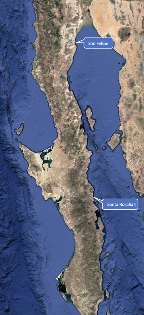
So, for my kayaking goal, I settled on what I thought could be a month-long trip from San Felipe in Baja California Norte to Santa Rosalia in Baja California Sur, a distance of approximately 340 miles along the most rugged section of Baja’s coastline.
Next:
Day 0 – Chasing the Horizon – An Adventure of a Lifetime Begins
Day 1 – San Felipe – Pushing off and Looking Back
Day 2– Sunrise on the Sea of Cortez
Day 3 –Just How Far is the Horizon?
Day 4 – Puertecitos: Resupply Water and Food!
Day 5 – The North Wind
Day 6– Passing the Vulcan Prieto
Day 7 – Tortilla Flats
Day 8 – Gonzaga Bay & Alfonsina’s
Day 9 – Gonzaga Bay
Day 10 – Punta Final
Day 11 – Cliffs & Coyotes
Day 12- Salsepuedes (“Get out if you can!”)
Day 13 – This Should Be “Baja National Park”
Day 14 – Canal de Ballenas & “Wretched Excess”
Day 15 – Spam is Good!
Day 16 – The Wine List
Day 17 – Where Are All the Fish?
Day 18 – God Must Live Here!
Day 19 – Other Kayakers on My Sea!
Day 20 – Bahia de San Rafael
Day 21– San Francisquito, Water!
Day 22 – El Barril, A Mirage in the Desert?
Day 23 – Stingrays and Jellyfish
Day 24 – Took a Shortcut, Wrong!
Day 25 – Hungry in Punta Trinidad
Day 26 – Destination Within Reach
Day 27 – A Dream Accomplished
Back to the beginning of Two Miles to the Horizon
Please comment on Two Miles to the Horizon


5 Responses
[…] Two Miles to the Horizon- Introduction […]
[…] Two Miles to the Horizon- Introduction […]
[…] Two Miles to the Horizon- Introduction […]
[…] Two Miles to the Horizon- Introduction to Sea of Cortez […]
[…] Two Miles to the Horizon- Introduction to Sea of Cortez […]