
Kayaking Sea of Cortez: How Far is the Horizon? – Day 3
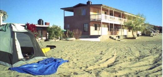
I woke up at my beach camp near Playa Hermosa to find a low tide that exposed a beach that had grown by about 200 yards in width, so I had a long haul to the water. The Sea of Cortez was dead calm for most of the first hour that I paddled.
I landed for a breakfast of potatoes and onions in foil, plus an orange. While I was writing in my journal, a man named Gene came up on his quad. He said he has had a house here for fourteen years and he’s been here six weeks this year. He has been all over Baja on a motorcycle. He said he was 70, but he looked much younger. Maybe it’s just relative because I’m 60 right now and 70 does not look that old, anymore. He said he was from Placerville, California, a town where I had done some environmental work on a proposed dam about 20 years ago. He said I was now about 35 miles by road south of San Felipe. He and his wife were leaving for home next weekend, but he was “not sure why”.
While we were talking, we watched large numbers of seagulls taking something off the water. The seagulls were feeding on what looked like large flying ants; Gene thought they were termites.
I stopped again at about 1:00 and cooked potatoes and onions on a fire. I had made another three or four miles. The water was flat calm and glassy, and it was humid and hot. The sky was cloudy all day and blended perfectly with the water surface, so it was impossible to see a definite horizon.
Paddling at a constant pace over long distances can be a hypnotic (some would say mind-numbing) activity, eyes fixed on a distant point on the horizon with only the sound of the very faintest of splashes as the paddle enters and exits the water. My goal was to fall into a rhythm of paddling when the most energy efficient and repetitious stroke I could achieve was about 50 strokes a minute, 3000 strokes an hour, 15,000 or more strokes on a good day! When I looked around at my world, I could see it consisted only of a horizon, water or shoreline and then sky, nothing more.
How far is the horizon, anyway?
How far could I see features on the water or breaking surf at the shore when I was sitting in the kayak? Like the calculation of tides, calculation of the distance to the visible horizon was of great importance to the early seafaring explorers. So, like tide tables, calculations for the distance to the horizon are available in tables for just about any height of an observer. Ignoring the effect of atmospheric distortion, the formula for calculating the distance to the visible horizon is the distance to the horizon in kilometers is approximately equal to 3.75 times the square root of the observer’s height in meters. From the tall masthead on a ship of, say, 60 feet in height a lookout can see the horizon out to about 10 miles. From my position sitting low in the kayak my horizon was only visible out to less than 2 miles!
To me the horizon was most impressive during sunrise. On most mornings I tried to be in my kayak before sunrise to get an early start and to avoid the heat of the day. Watching the sunrise from my kayak was a major daily event, bringing me to a complete stop while slowly drifting with the tide. Because of the clarity of the air and the almost total absence of clouds, a Baja sunrise starts at least an hour before you ever see the first sliver of the rising sun. The pre-dawn sky turns from black to a dark blue, then yellow and red, sometimes with beams or shadows in the red light caused by mountains or clouds far away across the Sea of Cortez and well below the horizon. The sky remains a bright crimson for a long time and then in an instant, it seems, the sun launches like a blazing rocket up from the water’s surface, brilliant and un-filtered by the clear sky of the Sea of Cortez. On many mornings the Sea is a limpid pool perfectly reflecting the sun, doubling the sun’s brilliance so that you must very soon shield your eyes. And, most amazing of all, this incredible display on the horizon is only two miles away!
As I made my way in the kayak, I was always about 2 miles from the horizon, never getting any closer, but slowly revealing beaches, birds, floating objects, and everything that came into my limited field of view as I tried to overtake the horizon. With constant paddling I could do about 3 miles per hour, meaning that I could reach the edge of my visible horizon in about 40 minutes. Looking back, I could only see the water’s surface as far as my most recent 40 minutes of travel, all else was lost in the distance. It was like moving through space within an existence that consisted of about 80 minutes of time, only 2 miles in front and 2 miles behind, constantly changing but never increasing. My life was bounded by the horizon, ever so close but never overtaken.
* * *
I finally made it to an area where the houses thinned out a bit but were still frequent enough that I had to watch where I stopped. By mid-afternoon, I landed near Campo Christina where I decided to spend the night. I spent some time on the beach checking the maps and the tide tables.
Reviewing my tide chart, the tides were starting to increase again and there will be a 13.8-foot tide tonight. I’ve pitched the tent a couple of feet above where I thought the last high tide had reached, it was a difficult haul up the beach. I have a long rope tied to the bow and I wrap the rope around my waist and haul the kayak up the beach, pulling like a donkey.
My safety equipment was minimal. For navigation, I knew that if I kept the shore to my right I would be heading south, so I really didn’t feel the need for any navigation equipment at all. I had purchased a deck compass for use in California where it was frequently foggy, and it would be useful there. I had originally thought of leaving the compass at home because I wanted to travel as lightly as possible (it only weighs a couple of ounces!!), but I ended up bringing it along. I had six maps covering my route so I thought I could always figure out where I was, within a few miles, anyway. Traveling down the coast, though, I did find the compass was useful for determining the direction of the wind. I was always on the lookout for the dreaded north wind, and it was helpful to know exactly which direction the wind was coming from.
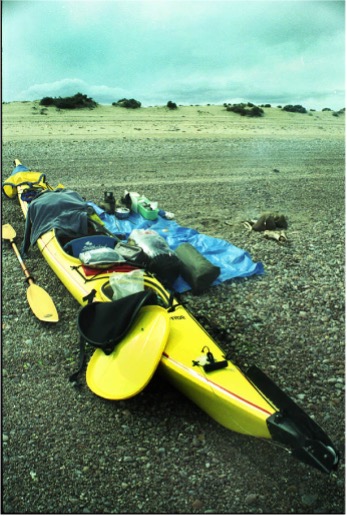
Aside from the life vest, I had a signal mirror tied to the vest pocket. Presumably I would be able to signal for help, using an aiming device built into the mirror. I also had a little inflatable pillow called a paddle float that I could use in case I capsized. The paddle float was to be inflated and attached to the end of a paddle that was then secured under the bungee cords on the deck of the kayak to form sort of an outrigger, with the float on the end. Because the kayak was impossible to climb back into if it turned over, the paddle float was essential to stabilize the kayak for a self-rescue. That was about it: life vest, mirror, paddle float.
In the late afternoon I noticed there were some mean looking clouds blowing in from the west and it looked very windy in that direction. The afternoon breeze from the southeast or east was strong late that afternoon, so I was glad that I had decided to pull in. The sun was hot earlier, even with a heavy overcast that obscured the horizon. Near my camp I found a 20-liter plastic fuel tank that I used for a table. Nice to be able to ease my aching back with some of the comforts of home, sort of. During my earlier kayak trips around Bahia de Los Angeles, I found that it was possible to find almost anything you wanted in the debris that accumulated in windrows on the beach. There was plenty of flotsam and jetsam along the high tide line and you just have to keep looking until you find what you want.
I was thinking about home and work. At work I had to leave behind a large project for other people to finish. I felt guilty, but, after 30 years of work, people must expect me to be a flake sometimes. At home, I hoped my wife was doing OK. She has to coordinate a big dinner on Saturday, so I guess she will have something to say about me and my Baja quest. I should be able to call her in about 4 days when I expected to be in Puertecitos, my first stop for water and food.
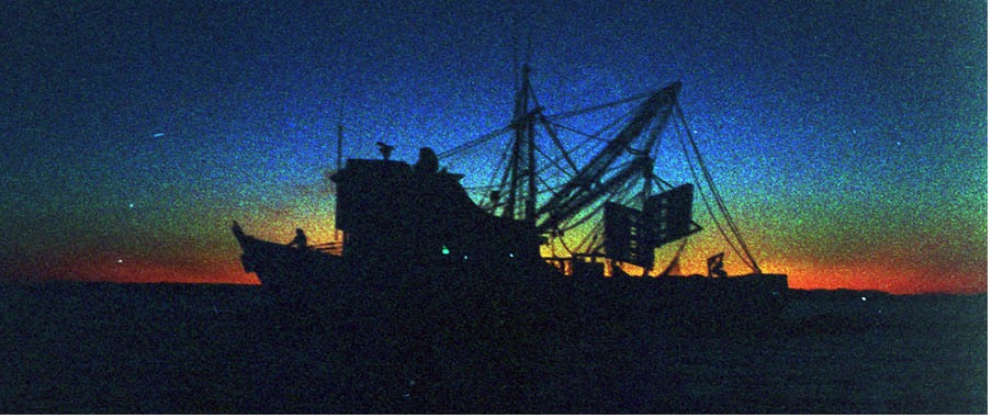
There were two large shrimp boats working back and forth about 5 miles off the coast. You can hear their motors groan in the distance. When they pull up the net there were hundreds of birds feeding on the shrimp, or maybe it’s fish that they bring up. I think that they drag the nets all night because there were offshore again just before dawn.
As I proceeded south along the coast, the beaches were becoming very rocky in the tidal zone and the rocks go out in shallow water for a couple hundred yards. It was becoming very hard to find any sandy spot to land when the tide was out.
I’ve been trying to think of a name for the kayak. What came to mind was “Mirage” after seeing the porpoise in the mirage the other morning. That was incredible. There was a nice sunset, with the sun peeking through the clouds and throwing rays from the west to the east.
When camping on the beach, I was always on the lookout for people, expecting someone to come by and charge me for staying on the beach, even though the beaches are public property in Mexico.
After dinner I got a shock when I looked down the beach at Campo Christina and saw that all the rocks were covered, and the tide was coming up very fast. I was not sure whether I was far enough up the beach, and I thought I might have to move the kayak a little farther up. (In the morning I checked the seaweed line found along the high tide line and I found I had just about a foot to spare before the kayak would have floated away.)
Next: Day 4 – Puertecitos: Resupply Water & Food
Please comment on Two Miles to the Horizon
Back to the beginning of Two Miles to the Horizon

2 Responses
[…] Next: March 7, Day 3 – Just How Far is the Horizon? […]
[…] Day 3 –Just How Far is the Horizon? […]