
Kayaking in Sea of Cortez: Cliffs & Coyotes – Day 11
I awoke early to resume kayaking in Sea of Cortez looked around at the rocky beach and campsite that I had carved out of the rocks on the southern edge of Punta Final. I launched as soon as get everything packed . The tide was not all the way down but there were still lots of rocks to cross, all embedded with sharp mica grains that tore away at the soft plastic of the kayak. I collected some driftwood and laid it in a path from my kayak to the water, hoping to cushion the kayak from the abrasive granite rocks.
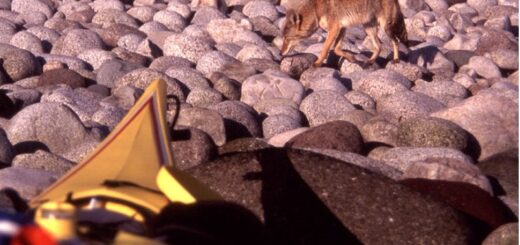
After pulling the kayak down closer to the water I went back to camp to pick up some stuff. There was a large coyote standing right in the middle of my camp, sniffing my stuff. I was about 10 ft. away yelling and clapping my hands. He didn’t move. I walked towards him and he ran a few feet up the hill to watch me from a safe spot. He looked about twice as big as the coyotes back home.
I paddled by the lagoon where I had hoped to land yesterday. There was a small stream flowing out of it at low tide. It was not a very deep passage and it’s no wonder that I couldn’t get through yesterday in the high surf. There were light northeast winds as I went down the coast. The waves were still quite large and they rebounded after crashing on shore to produce a very confused sea. Around each of the points the tidal currents caused waves to appear even when there was very little wind.
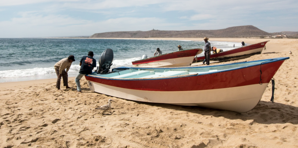
I landed at the Calamajue fish camp at about 9:15 after going about 8 miles. The long, low beach had some large surf, and I was quite proud of myself as I surfed in on a wave to the beach without turning over. I got my stove out and had soup. The fish camp is on a very wide, half-mile-long beach that was the first sandy beach I had seen in a long time that was sand all way down to low tide. This is the last large sandy beach for the next 50 miles, no doubt that was why the fish camp was established here in the first place. There were ten to fifteen shacks made mostly of cardboard on the upper part of the beach and there were about ten or fifteen pangas pulled up close to the shacks that were spread along the length of the beach. It was quite a large fish camp.
**********
Once, when we were visiting my wife’s relatives down in La Paz, I had an opportunity to visit an isolated fish camp, where I stayed for several nights with three Mexican fisherman. The camp had the look of a homeless encampment constructed from a few pieces of driftwood covered with cardboard and some plywood. Mostly it was just open to the wind and elements with a covered area of plywood and palm fronds and furnished with various boxes and barrels. A standard item in almost every fish camp is one or more salvaged refrigerators lying on its back and serving as a huge ice chest
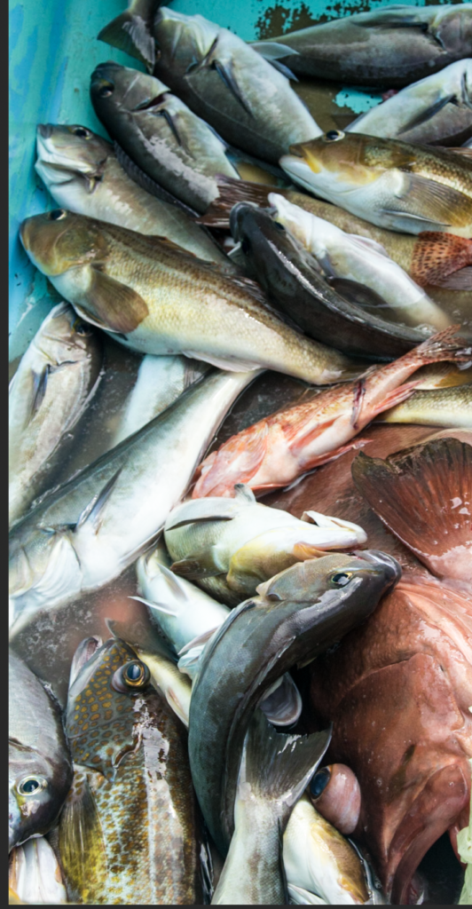
Days spent in the fish camp are part vacation, sleeping, cooking, baiting hooks and traps, entertainment, and survival. On the one hand, whenever there is a free moment and well into the night the fishermen play dominoes, drink, and tell an endless string of stories and jokes. Only Spanish was spoken at the fish camp I was at and, being that I only had two years of high school Spanish, there was always a hilarious and futile attempt to explain the punch line of every joke to me. On the other hand, the fishing work is demanding and often backbreaking. Fishermen can spend hours pulling in nets that weigh hundreds of pounds or diving for hours into the ocean to collect fish and invertebrates.
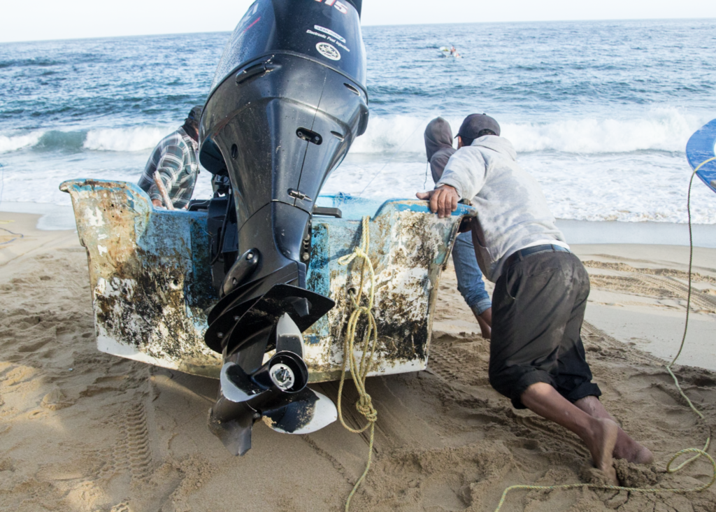
The camps themselves are often situated in idyllic locations, surrounded by stunning natural beauty and crystal-clear waters teeming with marine life. Large fish camps like the one at Calamajue, have a sense of community where the individual boat crews help each other launch through the surf. One common method they use when launching through big surf is to link the boats together with long ropes and launch them in sequence. After the first boat is launched it pulls the second boat through the surf, and the second boat pulls the next and that continues boat by boat until all have been launched.
The boats they launch, of course, are pangas. First designed and built of fiberglass in the early 1960’s in La Paz, Baja, the panga was simple – no inside floor, no cockpit, no extraneous features – but it was efficient and cost-effective, and it had superior handling and carrying capacity. A couple of guys with nets and longlines could go through the surf, travel 40 or 50 miles and bring back a sizable load in a boat that was easy to handle, stable, seaworthy, and very safe. The panga’s versatility and durability have made it an indispensable tool for fishing communities everywhere. Its flat bottom and shallow draft allow it to navigate through shallow waters, while its sturdy hull can withstand the rough waves of the open sea. With its modest size and low fuel consumption, the panga is an economical choice for fishermen who rely on their catch for their livelihood.
In many ways, the panga boat embodies the spirit of the fishing communities that created it. Its humble origins and practical design reflect the values of hard work, ingenuity, and a deep respect for the sea.
*****
After having my soup on the beach of Calamajue, I got back in the kayak, launched through the surf and headed south to continue kayaking in Sea of Cortez. After about 2 miles of paddling, I landed on a much smaller beach, but this time my landing was not quite so graceful. I took on about six as inches of water. It seems like every time I launch or land through the surf I have to dry my shirt and pants. My camp is often an assortment of clothes spread out under the sun on the rocks or on top of my tent.
As I continued south, steep tall cliffs lined the edges of every possible landing site where there was enough sand to form a narrow beach, sometimes only about ten feet wide. Most of the beaches had recent rockslides from the steep cliffs that towered high above. Big boulders from landslides were pushed way out to sea, and it was obvious that this edge of the Sea of Cortez was geologically active. Every beach was littered with falling rocks and it made me think about the possibility of being on one of these beaches when falling rocks obliterated it. I never actually saw rocks falling, so I considered the probability of being buried here to be relatively low. The steep cliffs and outcrops of volcanic rocks that characterize the eastern Baja California Peninsula has been caused by a slow but continuous uplift through eons of time. “The Wall” area is very close to the edge of a tectonic plate and ancient beach terraces can be found along the peninsula.
Guardian Angel Island was fully visible in the distance about 30 miles to the south. This very large island will be visible to me on my left horizon for the next 10 days or so. It rises to over 4000 feet and almost always has a lenticular cloud above it, possible caused by high winds crossing over it.
I landed one more time for a snack and then continued down to what I think was Ensenada Blanca. I had made about 17 miles today, some of which must have been against the tide. Some areas, especially off points, had very confused waves. Many times, I was in water that was just popping up and down, almost vibrating, and sometimes there were white caps with very little wind. In some places the water looked like almost like a river, coming toward me and seeming to be rushing towards the north to accommodate the high tide.
Soon I came to the area called The Wall, which seemed to go on forever in the distance. The cliffs where amazing, alternating layers of dark lava and lighter sedimentary rock. They were going straight up with jagged edges and peaks. I tried to see which types of rock were the steepest. I thought the dark rock areas were going to be the steepest, but then I came to a reddish cliff that went straight up. This was at the north end of Estero Blanca where I stopped for the day. That red cliff was composed of thin vertical layers about 1-2 inches in thickness and as those layers flaked off it formed a sheer cliff so straight and smooth it was finished like the polished granite face of a building, possibly 500 feet or more straight up. It was indeed “The Wall” and it was unbelievable.
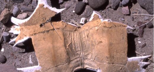
The place where I stopped for the night was in the middle of a series of beaches about 2 miles long. I explored the area north of my landing spot and found several whalebones. The local coyote was checking me out from a distance while I made dinner. I’ll have to secure all my stuff tonight because I’m sure he will be visiting. The man from Montana that I met a couple of days ago said these coyotes are very smart. He said, “We don’t allow them to be that smart in Montana”.
This evening at Ensenada Blanca the waves were considerably smaller than yesterday and if there was no wind tonight, the Sea of Cortez should be even flatter tomorrow. It’s surprising how fast the waves die down after the wind stops. Sometimes it seems that only a day after a strong wind the sea becomes flat and glassy.
Next: Day 12 – Salsepuedes (“Get out if you can!”)
Please comment on Two Miles to the Horizon
Back to the beginning of Two Miles to the Horizon


2 Responses
[…] Next story Day 11- Cliffs & Coyotes […]
[…] Day 11 – Cliffs & Coyotes […]