
Kayaking in Sea of Cortez: Punta Final – Day 10
The wind blew hard all night at my camping site near the cluster of trailers called Campo Punta Final, but there was only a light breeze in the morning. There were quite a few clouds and it looked like there was wind on the water in the distance. There was fine sand in the tent from the heavy winds last night. A day like the stormy one yesterday made me think “This is kayaking in Sea of Cortez, am I crazy to do this by myself? Have I been watching too much Discovery Channel?”
I had made only about 7 miles yesterday, traveling from Alfonsina’s to the south end of Gonzaga Bay, so I decided to launch even though the waves were huge and breaking quite high on the beach. Although the wind was light in the morning, large waves were still coming in from across the Sea of Cortez, and it would probably take a couple of days before they would flatten out. I stood on the beach a long time studying how the waves were breaking, trying to see if there was a pattern with smaller waves that might make a launch possible. My normal way of launching was to push the kayak into the surf while standing next to it, and then jump in and paddle like crazy to get through the breaking waves and into deeper water. That means that I don’t have the skirt firmly attached to the kayak when the first waves hit me and as water comes over the bow it floods into the cockpit. This was the biggest surf I had attempted for a launch and after I got through the breakers the kayak was flooded with about 4 inches of water. I had to pump it out using the bilge pump and of course my clothes remained soaked with salt water until my next stop. I was quite proud of myself though because I had made it through surf that was so big that it made my jaw drop when I first saw it in the morning.
Punta Final was the beginning of a 50-mile section of the Baja coast that some call “the wall”, and it was a place that I have been concerned about ever since I started planning this trip on the Sea of Cortez. Punta Final was at the edge of civilization, and I was hoping that by the time I got here I would be sufficiently skilled with the kayak to make it on my own. There was no doubt about it, I was on my own after passing Punta Final. It was about 75 miles to Bahia de Los Angeles and there was only one small fish camp of note (called Calamajue) about 8 miles from Punta Final, after that …nothing. There are very few people that travel by boat along this uninhabited section of Baja and there would be no hope of help if anything went wrong. Ed Darack, in his book “Wind Water Sun”, described it as follows:
“This is one of Baja California’s loneliest places. It is not only remote, but dangerous. A 50-mile wall of rock is the best brief summary of the stretch of coast between Calamajue and Punta Remedios. This is one of the least visited stretches of coast on the entire peninsula. The mountains along this coastline rise formidably out of the surf along this coastal strip. With almost no sandy beaches…. there are few places to land anything but a kayak or a very small boat here.”
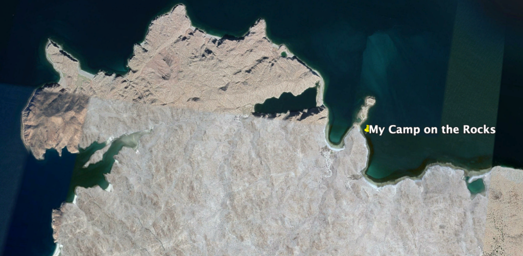
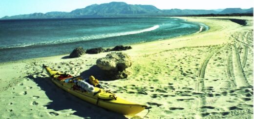
Punta Final is a series of about five separate points that need to be rounded, with deep coves and lagoons between them. As I approached the first point, the waves got bigger, and I put on my life preserver. Normally I didn’t wear my life preserver, but these waves were frightening and I knew I was testing the very limit of my ability to keep from capsizing. Each point had huge breaking waves and no beach had any sand that I could see. Instead there were rocks and boulders everywhere with waves crashing heavily on them. I went from one point to the next looking for a suitable landing spot. Some of my maps had indicated there was a lagoon near the south end of these points (shown in the far right of the photo, above). When I got there, the entrance to the lagoon was only 10 or 20 feet wide and there were huge waves crashing through it. I was tired and couldn’t go on because of the high waves, so I backtracked almost a mile to a rocky beach that was protected from the worst of the waves. I landed without too much trouble, but as I struggled to drag the kayak over the sharp rocks and barnacles I didn’t want to think about the damage the rocks were doing to the bottom of my kayak. I had duct tape for making repairs, just in case, but that was little comfort.
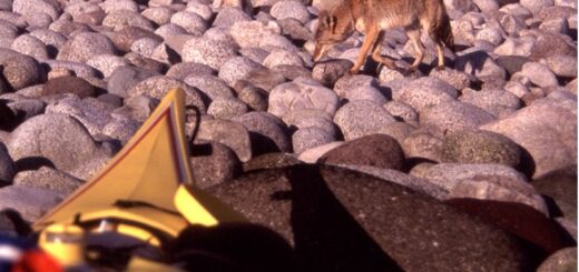
This was kind of an interesting spot. The “rock roaches” (isopods) were everywhere and move in the thousands like small armies across the rocky shore. They move up and down with the tides, almost blanketing the rocks. Beyond the isopod army on the rocks, there was a big pelican feeding frenzy about 100 yards offshore. The rocks were made of decomposed granite, the first I’d seen, and was like a destructive sandpaper on the bottom of my kayak. Up to now the rocks in the upper Sea of Cortez have been mostly lava for volcanos, or sedimentary materials made from silt that originated from the Colorado River. I explored the point and climbed up to a high lookout spot where there were some small elephant trees. The elephant trees have a large swelling or bulb on their lower part, a bit like a giant onion.
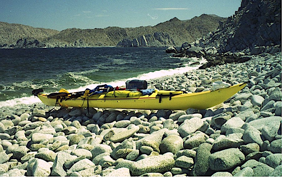
I had pulled the kayak up as far as I could do to get to a level spot, hoping it was above the high tide that I expected in the night. Then I had to move some large rocks and boulders to uncover some sand and make a level area big enough for me to pitch my tent. As the tide went down, I walked out on some small rocky islands that emerged from the falling tide. These small islands were made of decomposed granite, and they had deep holes and pits from wind and water erosion. There were lots of shiny flakes of mica in the granite, which was very coarse. I scanned the area with my binoculars and across the bay was a very high sheer cliff with smooth faces and fissures that made triangular sections. I noticed that the water in the deep areas around these points was the color of thin tea. I thought there must be a phytoplankton in this area that makes the water that dark.
As the tide went down it exposed a long rocky shoreline next to my camp. In the morning the tide would be lower again and I’ll have to drag the kayak across this gauntlet of rocks. From my tide charts it looks like low tide will be at about 7:36 tomorrow morning. I planned to get up early in the morning and get packed quickly so I could get off these rocks before the tide was so far down that I would have to face an even longer haul across the rocks.
Next: Day 11 – Cliffs & Coyotes
Please comment on Two Miles to the Horizon
Back to the beginning of Two Miles to the Horizon

2 Responses
[…] Next: Day 10 – Punta Final […]
[…] Day 10 – Punta Final […]