Kayaking in Sea of Cortez: Bahia de San Rafael – Day 20
I awoke in the morning to the sound of the trawlers that had been working all offshore in Bahia San Rafael. Made breakfast of tortillas and jam, they taste so good along with the coffee. I should have gotten a larger jar of jam; my body seems to crave the sugar.
The shoreline here was so interesting. There’s a cliff about 20 feet high and at the base there is a layer of sand dollars about three or 4 feet thick, and then a very wide expanse of rock going out to sea about 100 or 200 feet that was exposed at low tide, with lots of rocky formations offshore. I think these rocky formations must be a very good area for lobsters, though I didn’t see any.
The moon will be full in about four days, and I could see the heights of the tides were starting to increase. I thought I had pulled the kayak up far enough on the beach last night, but the tide line came up underneath the kayak all the way to the aft hatch. I must remember the first rule of survival here is “Don’t lose the kayak!” So, every night I tied the rope from the kayak to the tent, hoping that the kayak would pull on the tent and wake me up if the tide tries to take my kayak away.
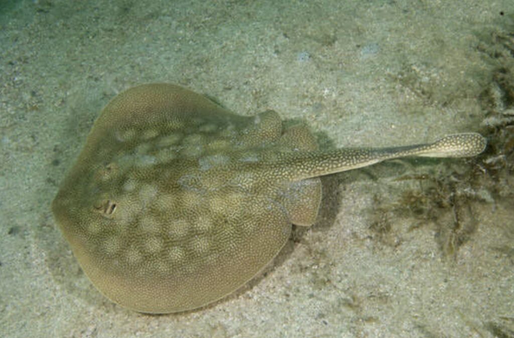
I explored the backcountry, cliffs composed of fluvial deposits, lava sprinkled on top, and some sand dunes. Lots of animal tracks and droppings from burros. After my hike, I decided to take a bath at the shoreline, and while standing there in about 6 inches of water, I saw seven stingrays lined up in front of me, each about 1 foot in diameter. As I looked around, I realized there was a virtual gauntlet of stingrays waiting for me every time I stepped into the water. This changed my whole concept of a safe sandy beach landing. I was now going to be more cautious every time I put my foot in the water beside the kayak.
I launched the kayak and continued down the coast for about 5 miles with the same rocky shelf and fossil sand dollar deposits at the high tide line. The rocky formations of fossil sand dollars have been dated in some areas of the Baja coast as being formed about 125,000 years before present. I passed a strange rock wall that someone had built straight up the side of the steep volcanic hill. The wall is about 5 ft. wide and about a quarter mile long going up 300 or 400 ft. in elevation from the shoreline. My first thought was that this was marking the border between northern (Baja Norte) and southern Baja (Baja Sur) but, checking my maps, I was still far north of that point. This wall was a mystery to me because it obviously took a lot of work to build. When I later talked to others who had seen the wall, they thought it was a rancher who built the wall to keep his cattle from straying down the coast.
I stopped at a deserted fish camp, and I found a pot that I might be able to use for a still to produce some fresh water. I found this whole coastline to be very interesting. Lots of oyster shells, some different kinds of seaweed, and little clouds of drifting filamentous algae. One of the new kinds of seaweed that I saw had “leaves” that were filled with water and a little bubble at the top. Some were up to a foot long, and when they broke off, they would float.
It was a great day of kayaking; winds were light and the skies clear. I did have to use the pump after one launch in some waves where I took on a bit of water. It was very slow kayaking today because I was constantly looking down at the bottom for fish, coral, algae, and whatever. At one point I came into a beautiful little cove along what I thought was a straight sandy beach. The cove was hidden behind some rocks, and as I went around the rocks and discovered this little jewel of a cove, I kept saying to myself “This is really off the scale!”, over and over. It was very beautiful.
When I finally landed, I was at a point that was within one day of San Francisquito, where I thought there might be water. If there was no water, that would be trouble, so I thought I’d better try to make a still to boil seawater and see if I could make fresh water. I guess this shows my poor planning, because it was late for me to be finding out if I can make water to survive. I used the pot that I had found at the fish camp and some old frijoles cans, plus a plastic pipe about 10 ft. long that I had brought from home just for this purpose. I cut a hole in the cans and attached the pipe and inverted the can in a pot of boiling water. I placed a rock on the can to hold it down and the can would collect steam ans direct it down the long pipe, hopefully condensing into fresh water and dripping int a cup. I spent about two hours trying to make the still work. I burned great quantities of firewood and I only got about one cup of water. The water tasted sweet but smoky. I think I learned a few things from this trial and maybe I can use this for emergencies. The worst part was after an hour of gathering wood and stoking the fire, I looked out at the beach and sky and saw this beautiful scene that I was missing. It was like being at work and not being able to enjoy anything.
Here is a drawing from my diary of the distilled water setup.

Next: Day 21 – San Francisquito, Water!
Please comment on Two Miles to the Horizon
Back to the beginning of Two Miles to the Horizon



2 Responses
[…] Day 20 – Bahia de San Rafael […]
[…] Kayaking in Sea of Cortez: Bahia de San Rafael – Day 20 […]